Clouds, often seen as mere accessories to a blue sky, play a monumental role in predicting our weather. Since ancient times, clouds have served as nature’s forecasters, indicating what the atmosphere intends to do next. But what makes clouds such crucial indicators of upcoming weather?
The Basics of Cloud Formation
At the very heart of cloud formation lie three critical elements: moisture, temperature, and air pressure. As the sun heats the Earth, it causes water from oceans, lakes, and rivers to evaporate, introducing moisture into the air.
When this moist air rises and meets cooler atmospheric temperatures, condensation occurs, leading to the formation of clouds. Central to this process is the role of cloud nuclei – tiny particles, like dust or salt, around which water droplets condense.
Different Types of Clouds and Their Significance
- Cirrus Clouds (Ci): Resembling wispy hair strands, these clouds often appear high in the sky. Their presence frequently signals that a change in weather is imminent, often heralding a front’s approach.
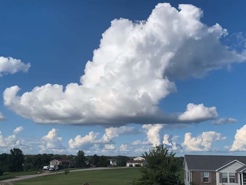
- Cumulus Clouds (Cu): These fluffy, cotton-like clouds typically indicate fair weather. However, when they grow taller and larger, it’s a sign they could evolve into stormy cumulonimbus clouds.
- Stratus Clouds (St): These are low, gray clouds that cover the sky like a blanket, leading to overcast conditions. While they don’t necessarily predict storms, their presence often means light rain or drizzle.
- Nimbostratus Clouds (Ns): Thicker than stratus clouds, they blanket the sky and bring with them continuous, steady precipitation.
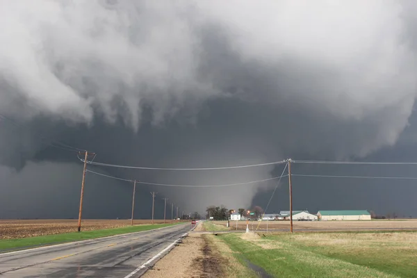
- Cumulonimbus Clouds (Cb): Towering and ominous, these clouds are responsible for thunderstorms, heavy rains, and other severe weather events. Spotting one means it’s time to take cover!
Other clouds, such as stratocumulus, altocumulus, and altostratus, have their unique tales to tell, with each offering clues about the atmosphere’s current state.
Clouds as Precursors to Specific Weather Events
Meteorologists closely monitor cloud patterns to predict upcoming weather events. For instance:
- The progression from cumulus to cumulonimbus can indicate an approaching thunderstorm.
- A surge in cirrus clouds might precede rain or snow within the next 24 hours.
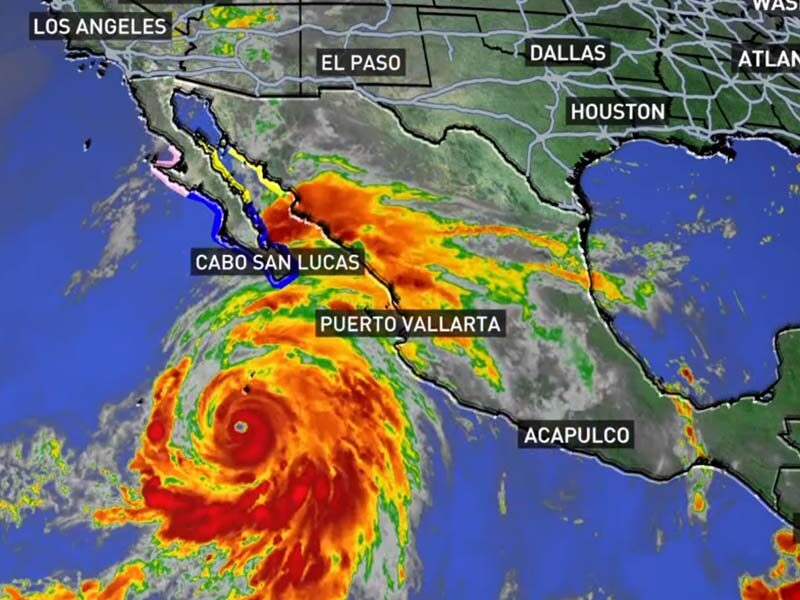
- Specific cloud spirals and formations can warn of potential tornadoes or the approach of hurricanes.
Modern Techniques for Cloud Observation
Modern techniques for cloud observation have considerably advanced our understanding of atmospheric processes and improved weather forecasting accuracy. Here’s a deeper look at some of these techniques:
Satellite Imagery
- Geostationary Satellites: Positioned at a fixed point above the Earth, these satellites provide continuous monitoring of cloud patterns, making them invaluable for tracking the development and movement of weather systems in real-time.
- Polar-Orbiting Satellites: These satellites circle the Earth in a north-south orbit, passing over both poles. They offer global coverage and are especially useful for monitoring cloud cover in polar regions.
- Multispectral Imaging: Modern satellites can capture images in multiple wavelengths (visible, infrared, ultraviolet, etc.), allowing meteorologists to observe cloud characteristics that aren’t visible to the naked eye.
Radar Systems
- Weather Radars: These are ground-based systems that send out radio waves to detect clouds and precipitation. By measuring the time it takes for the radio wave to return and its change in frequency (Doppler effect), meteorologists can determine the location, movement, and type of precipitation.
- Cloud Radars: These specialized radars operate at higher frequencies and can detect finer cloud particles, giving detailed insights into cloud structures and layers.
LIDAR (Light Detection and Ranging)
This ground-based tool emits pulses of light (laser) into the atmosphere. By measuring the time taken for the light to return after hitting particles in the atmosphere, LIDAR can create high-resolution profiles of cloud layers, aerosols, and other atmospheric constituents.
Drones (Unmanned Aerial Vehicles)
Drones equipped with sensors and cameras can be flown into cloud systems to gather data. They are especially useful for studying cloud microphysics in areas that might be risky for manned aircraft, such as the cores of hurricanes or during intense thunderstorms.
Weather Balloons (Radiosondes)
While not a new technology, weather balloons equipped with modern sensors (radiosondes) are launched daily from various locations worldwide. As they ascend, they transmit data about temperature, humidity, pressure, and cloud heights back to ground stations.
Cloud Cameras and Ceilometers
Cloud cameras capture images of the sky at regular intervals and are often used at airports to monitor cloud cover and other sky conditions.
Ceilometers are devices that use a laser or other light source to measure the height of a cloud base.
Aircraft-Based Observations
Research aircraft are sometimes deployed into specific cloud systems to gather direct measurements. These aircraft are equipped with advanced instruments that can sample cloud particles, measure wind speeds, and more.
Ground-Based Observational Networks
Many countries have established networks of observational stations that continuously monitor cloud cover, type, and other related parameters. These observations contribute to global cloud datasets, enhancing weather models and forecasts.
The Role of Technology and Cloud Prediction
As technology advances, so does our capability to predict weather based on cloud data. Artificial intelligence and machine learning algorithms analyze vast amounts of cloud data, enabling meteorologists to make more accurate, localized, and timely weather predictions. Current research promises even more refined tools for cloud-based forecasting in the near future.
Limitations and Challenges
However, cloud behavior can sometimes be unpredictable. Furthermore, with climate change influencing atmospheric conditions, established patterns might change, posing new challenges for weather prediction.
Summary
In essence, the ever-changing tableau of clouds holds tales of atmospheric intent. Observing and understanding them not only arms us with knowledge of imminent weather but also connects us to the age-old practice of reading the sky’s narrative. So, next time you gaze upwards, know that you’re looking at nature’s most dynamic storytellers.